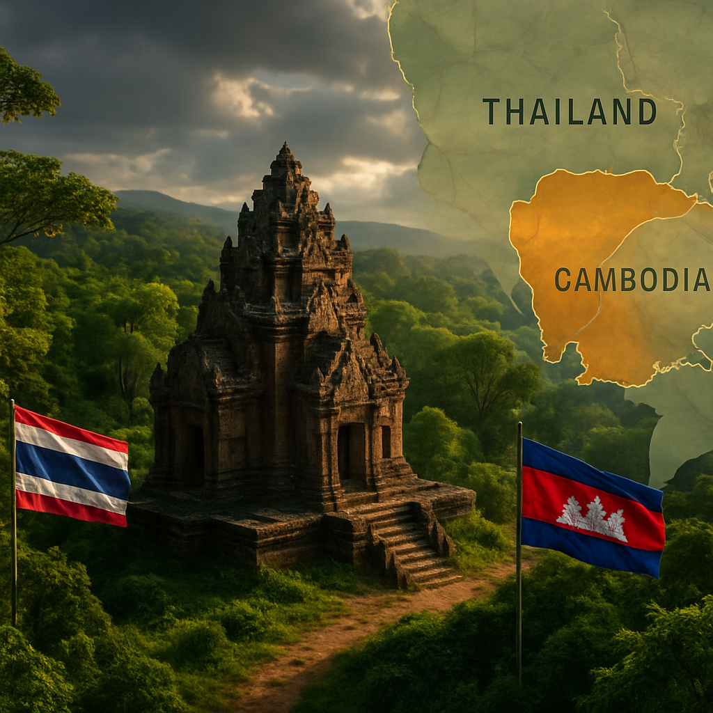
Lying peacefully yet prominently in Surin province, the Ta Muen Thom temple is at the beating heart of this historical tug-of-war. As passions flare, Major General Winthai Suvaree of the RTA emerges as the voice of furious clarity, declaring to all who will listen that “many locations marked on Google Earth and Google Maps are inaccurate.” A bold statement! But the RTA believes that amidst today’s digital cartography woes, these virtual labels hold as much legal power as wishes in the wind.
The General’s proclamation sounds almost like a soothing lullaby to ears in Thailand, as he lovingly cradles the idea that Ta Muean Thom symbolizes Thailand’s “historical and geographical sovereignty.” The temple’s journey through history, from a Thai archaeological marvel in 1935 to its pivotal place in modern territorial debates, adds an air of intrigue and depth to the narrative.
Supporting Thailand’s claim is the unwavering affection of the Fine Arts Department, which has tenderly refurbished the ancient ruins, like carefully restoring an old but cherished family heirloom. Even Cambodian officials, mindful of the delicacy required in such matters, have reportedly given the nod of acknowledgment to this restoration work. In an act of love and commitment, the Tourism Authority of Thailand has paved—quite literally—a road leading right to the temple’s doorsteps, showcasing it like a crown jewel. Meanwhile, artefacts unearthed from the site now have pride of place at the Surin National Museum, surrounded by an awe-stricken audience.
Yet, the plot thickens! Let us fast forward to the International Court of Justice, where the temple’s saga continues to unfold. Here we find ourselves at an impasse, with Thailand standing firm and unyielding, refusing to acknowledge the court’s jurisdiction over this sacred dispute. How very Shakespearean!
Enter Deputy Defence Minister General Natthapon Nakpanich—a character adding both hope and complexity to this tale—who gingerly extends an olive branch to Cambodia, suggesting the resumption of informal yet significant bilateral talks. “There has been a positive development,” General Natthapon optimistically notes, infusing the air with a sense of relief amid unresolved tensions.
Interestingly, despite the bubbling cauldron of contention, Thailand has cleverly avoided sealing its border with Cambodia, only adjusting the opening hours—a diplomatic dance that might rankle some but pleases others. Meanwhile, Cambodia’s response is the oh-so-dramatic curtain fall, as it temporarily closes its border with Thailand.
And so, the curtain falls on another act in this captivating play of geographical destiny—an epic slowly unraveling but ever-rich in historical significance. As the centuries-old ruins of Ta Muen Thom stand resolute, they remain a poignant emblem of a region brimming with overlapping narratives and fiery nationalistic passions.
Even as tensions simmer just below boiling point, the story of Ta Muen Thom captures the imagination and loyalties of the people entwined. A monument holding time and territory in balance, it’s an eternal reminder that sometimes where stones lie, stories rise.
Through this lens, the surrounding chatter becomes almost white noise—a wild, cacophonous backdrop for the central tale of heritage and human perseverance. What will happen next in this saga of heartbeats and historical claims? Only time, perhaps guided by Google Maps and the spirit of diplomacy, will tell.


I find it quite hilarious that countries blame Google Maps for their territorial issues. Isn’t it the responsibility of the nations involved to sort this out first rather than pointing fingers?
You might think it’s funny, but maps play a huge role in international disputes! Misleading maps can have real-world consequences.
While I see your point, shouldn’t diplomatic talks be a priority over digital maps? Relying on them seems like a modern crutch.
Diplomacy is always the best approach, but sometimes you need to draw the line somewhere, pun intended!
It’s sad to see such beautiful historical sites entangled in political tensions. Ta Muen Thom should be preserved with respect to both cultures.
Agreed! Cultural heritage should bring us together, not drive us apart. But national pride can cloud judgment.
Exactly. Both nations should find a middle ground where historical appreciation prevails over ownership claims.
Not sure why Cambodia closed the border. Isn’t diplomacy about open borders and negotiations?
Closing the border might be a strategic move to pressure Thailand into discussions. It’s all about leverage, right?
True, but it just feeds into the tension. Maybe it’s about showing strength.
I get why Google Maps would be a scapegoat here, but what about the International Court of Justice? Thailand ignoring its jurisdiction is quite sketchy.
Ignoring the ICJ isn’t unusual for states with conflicting interests. Sometimes, it’s about who can assert power rather than abide by court rulings.
That makes sense, but it sets a poor precedent for resolving international disputes.
It’s pretty obvious Ta Muen Thom belongs to Cambodia, anyone can see that from historical evidence!
Historical evidence is interpretative and influenced by nationalism. Thailand has legitimate claims too!
Well, both sides should respect the facts, but it feels like one is hiding behind digital maps!
These digital cartography issues are interesting but isn’t the real issue the lack of effective dialogue between the countries?
While true, accurate maps are a stepping stone for meaningful dialogue. Both go hand in hand.
Google should be neutral. Their error can heighten tensions, even more, proving how tech companies hold inadvertent diplomacy power.
This is why context matters. Google Maps is not infallible, and using it to settle a dispute is a bit like using Wikipedia as a source for a PhD.
What’s missing here is empathy for both nations. This shouldn’t be about who owns a temple but how we can appreciate shared history.
How absurd is it to realize that ancient stones are still causing ripples in today’s global arena?! History’s not just in the past!
If anything, this shows reliance on corporations for things they have no business resolving—territorial disputes need human intervention.
Absolutely! It’s scary to think how much we depend on these tech companies to define our world.
Perhaps we need a new way to conceptualize borders where cultural heritage is concerned so we can move past such disputes.
There’s no accounting for the emotional weight of history, which often outweighs dry legal or cartographic claims.
I’m hoping General Natthapon’s talks with Cambodia lead to some common ground. Too many people get caught in the crossfire of politics.
If only history was as easily edited as a Google Map—our leaders would have one less excuse to fight.
What responsibility does Google have in ensuring cultural sites are mapped accurately? It seems like they should at least consult with local experts.