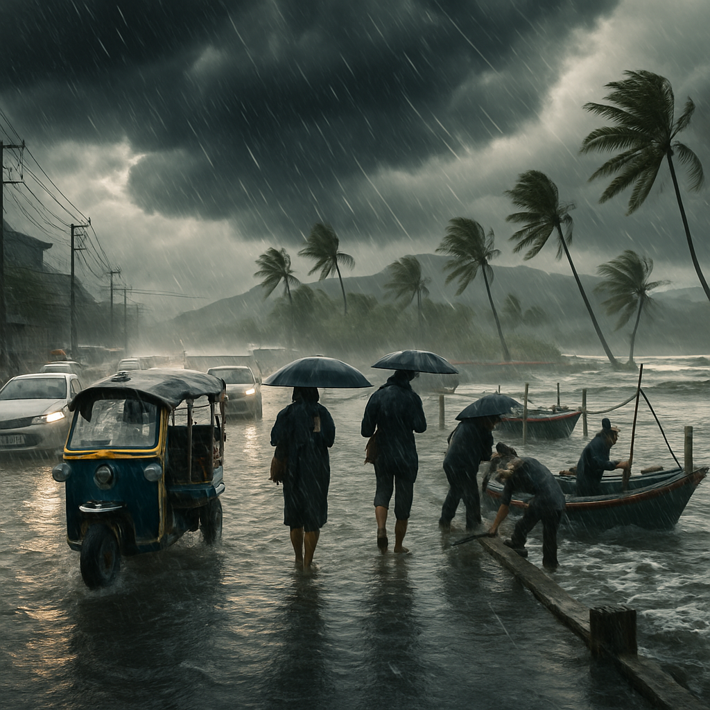
The monsoon has RSVP’d, and it brought a dramatic entrance. A broad rain system is sweeping across Thailand, drenching coasts and inland provinces alike and churning up choppy seas. The Thai Meteorological Department (TMD) is sounding the alarm: expect heavy to very heavy downpours, flash floods, and swelled waterways — especially along foothills, riverbanks and other low-lying spots. If you live in (or are headed to) Rayong, Chanthaburi, Trat or even Bangkok, prepare for soggy streets and sudden puddles that mean business.
At sea, conditions are anything but placid. The upper Andaman Sea and the upper Gulf of Thailand are forecast to throw up 2-metre waves, with surf rising even higher during thunderstorms. The lower Andaman will see 1–2 metre swells that can climb above 2 metres when storms brew. The TMD has urged all vessels — from rusty fishing boats to pleasure cruisers — to avoid thunder-prone zones and exercise caution. Fishermen and beachgoers, take note: the ocean will be moody and unpredictable for the next 24–48 hours.
One name you might have seen in headlines — Mitag — has already lost some steam. The tropical storm that hovered over Guangdong, China has weakened to a tropical depression and is expected to fizzle out soon. That’s good news, but it’s not an invitation to get complacent. Local conditions can change quickly; checking the latest forecasts before you set out remains essential.
Snapshot: Forecast from 6am Sept 20 to 6am Sept 21
- North: Fairly widespread thundershowers with pockets of heavy rain are expected across provinces from Mae Hong Son and Chiang Mai to Phitsanulok and Phetchabun. Temperatures will dip to 22–25°C overnight and warm to 29–33°C by day. Winds should be light and variable (5–15 km/h), but don’t let the calm fool you — the skies could erupt at any hour.
- Northeast: Scattered thundershowers with isolated heavy falls in Loei, Nong Khai, Udon Thani and neighbouring areas. Morning lows of 23–25°C, highs around 31–33°C. Winds variable at 10–15 km/h. Good weather window? Not really — expect intermittent rain throughout the day.
- Central: Provinces such as Nakhon Sawan, Lop Buri, Ayutthaya and Kanchanaburi will see fairly widespread thundershowers and isolated heavy rain. Early temps 23–25°C, climbing to 32–34°C. Winds 10–15 km/h; urban flash flooding is possible, so drivers in Bangkok’s outer areas should plan extra time.
- East: The eastern seaboard — Chon Buri, Rayong, Chanthaburi and Trat included — faces fairly widespread storms and isolated heavy downpours. Temperatures between 23–27°C overnight and 31–34°C daytime. Stronger southwesterly winds (20–35 km/h) with sea waves around 2 metres, rising during thunder. Beach days here are on hold.
- South (east and west coasts): Scattered thundershowers along the east coast (Phetchaburi to Surat Thani) with daytime highs of 33–36°C and coastal waves 1–2 metres, bigger during storms. On the west coast (Ranong, Phangnga and southward), expect similar conditions — waves near 2 metres and winds 15–35 km/h depending on the stretch.
- Bangkok metropolitan area: Scattered thundershowers and isolated heavy rain through the day. Low 25–27°C, high 32–35°C with southwesterly winds at about 10–15 km/h. Urban flooding and traffic snarls are likely, so leave early and carry an umbrella that won’t collapse under pressure.
Practical tips for residents and travellers:
- Keep an eye on updates from the TMD and local emergency channels — conditions can change rapidly.
- Avoid driving through flooded roads; even shallow water can stall a car or hide hazards.
- If you live near foothills or rivers, prepare to move to higher ground if flash flood warnings are issued.
- Boaters and fishermen: postpone non-essential trips, secure vessels, and steer clear of thunderstorm clusters.
- Tourists: check ferry and flight schedules, and expect last-minute cancellations. Pack waterproof gear and be flexible with itineraries.
The monsoon’s arrival always brings a mix of inconvenience and spectacle — thunderheads rolling in dramatics, rivers suddenly alive, and beaches wearing a wilder face. Treat this spell like nature’s stern reminder to respect the elements: prepare, keep informed, and stay safe. If you’re in the path of the rain, make sure your rubber boots are handy and your sense of adventure is waterproof.


")


This is not just wet roads — this is infrastructure failure showing up in real time, and Bangkok gets to watch every low spot become a canal.
They keep promising drainage projects and then a single storm turns Sukhumvit into a river, so where did the money go?
Exactly, and it’s not always corruption — sometimes it’s poor planning and short political cycles that kill long-term resilience projects.
Short political cycles excuse is real but people also need to stop building in floodplains like it’s optional land.
I drove through three flooded intersections last month and the city gave me a ticket for honking, not for putting up signs.
That ticket sounds petty, and it shows priorities are out of sync with emergency needs.
Funny, officials love enforcing small rules when the big ones are the problem.
The monsoon shifts are consistent with a warming climate increasing moisture convergence and convective potential; call it what you will, the atmosphere holds more water.
Agreed, but local land use and urban heat islands amplify rainfall intensity over cities like Bangkok.
Absolutely, urban planning must reflect these physical realities or else adaptation will be forever inadequate.
I’m skeptical of blaming every thunderstorm on climate change; weather is variable and we risk policy fatigue if we over-attribute.
There’s nuance: single events are weather, but the statistical increase in extremes is a climate signal and should inform policy.
Farmers are already stressed by erratic rains; too much now means young fruit drops and losses later.
My rice paddies are happy to get water but the heavy bursts ruin transplant beds and seedbeds in the lowlands.
We need better water storage between storms, not just reactive sandbags after the fact.
Government subsidies for storage would help but also encourage monoculture that destroys resilience.
Booked a ferry to Koh Chang tomorrow and now I’m wondering if I should just stay in Bangkok and sulk.
Last time I ignored the TMD I got stranded on an island for two days with no phone signal, learn from my mistakes.
Ugh thanks for the scar story, I just called the operator and they pushed my trip to next week.
Sometimes the delays are the best part of travel, you see new things and meet locals who gossip about weather patterns.
If you go, pack dry bags and a change of shoes; nothing worse than soggy socks on a delayed trip.
Traffic plus rain equals existential dread; every office should allow remote work on heavy rain days.
Remote work helps, but many service jobs can’t function remotely and those workers get the worst commute.
True, and the people who can shift to home often don’t, so the policy has to include protections for the rest.
Relax, buy a tuk-tuk for rainy day fares and make a killing, rain economy is real sometimes.
The sea warnings are not a joke, my crew had a boat capsized two years ago in ‘just a small storm’ and we lost gear.
Local fishermen often ignore weather bulletins because livelihoods depend on daily catch, it’s a tragic risk calculus.
They should be offered alternative income or temporary relief so they don’t risk lives for a market day.
But don’t smaller boats just stay in? I see them out and worry every time I swim near the pier.
Some captains are desperate or arrogant, and some think thunder is cute until it becomes fatal.
Why are we still surprised by monsoon season? It’s not a plot, it’s annual.
People complain but refuse to clear gutters and drains in their neighborhoods, so community laziness matters too.
Blaming neighbors is easy but sometimes drainage systems are just inadequate by design.
Still, if everyone did small maintenance, the worst local pooling could be reduced.
The wave heights quoted align with the southwesterly monsoon fetch from the Andaman; mariners should treat 2m as conservative in squalls.
Yes, and when convective storms superimpose on the monsoon flow, localized pockets of 3–4m can form quickly.
Those pockets are the killer for small vessels because they aren’t captured in coarse forecast grids.
Grid or no grid, we read the sky and the barometer; both are warning instruments if you know how to look.
Tourists who post ‘rain ruined my beach day’ make me angry; the sea does what it wants and people should respect local warnings.
Some tourists genuinely don’t know, and it’s on tour agencies to inform and refund when it’s unsafe.
Agencies should lose license if they keep sending people out into known dangerous seas.
As a tourist I admit some of us are clueless, but scolding isn’t helpful without guidance on what to do.
My house near the canal floods every year; I patched walls and they still leak like a sieve.
You could try elevating valuables and getting community sandbags; it’s not perfect but buys time.
We did sandbags last time and they held for 12 hours, then the water just seeped through concrete cracks.
Long-term the solution is coordinated canal dredging and better watershed management, but that’s expensive.
Packing waterproof gear is basic advice, but if flights and ferries are canceled, most travelers will be stranded and out of pocket.
Airlines barely refund anything, so travel insurance should be mandatory for all seasons here.
Exactly, and insurance companies should make clear what ‘acts of nature’ cover actually includes for monsoon disruptions.
Tour operators sometimes bribe port officials to run boats during warnings, that’s a scandal no one talks about.
As a teacher, my students are excited about indoor thunderstorms; they think it’s cool but parents worry.
Kids love dramatic weather, but schools should have solid shelter plans and communication with parents.
We conduct drills, but parents still want instant updates which is hard to manage in rural areas.
Some of the warnings feel dramatic and scare away customers, but safety first if the seas are truly rough.
Better to be alive and broke than dead and famous; tough economics but true.
Community funds for lost days might be a solution, but collecting and distributing fairly is tricky.
I think social media spreads panic more than helpful info; people post every puddle like it’s apocalyptic.
Social media also warns people to avoid certain roads, so it’s not all bad.
True, but the noise makes it harder to find official updates among the memes and outrage.
Official channels should leverage social platforms with verified alerts to cut through the clutter.
Why do forecasts still have huge error margins? I need specifics to plan harvests, not vague warnings.
Forecast precision depends on model resolution, observational data, and chaotic atmosphere; we can improve but can’t be perfect.
I get the science answer, but on the ground I need practical thresholds: if X mm predicted, move seedlings.
Local authorities could publish simple action thresholds for farmers and fishermen to remove guesswork.
Cyclists in the city are mostly ignored in warnings, but slick roads are a real death trap for two-wheelers.
We need more covered bike lanes and public education about braking on wet surfaces.
Covered lanes would be a dream, but even simple anti-slip paint on key turns would help.
One more point: small businesses on the coast shouldn’t be expected to stay open when waves are big and insurance won’t pay.
That’s where micro-insurance and community emergency funds could be a game changer if implemented well.
Micro-insurance exists but uptake is low because payouts are slow and claims processes are opaque.