GPS Gone Rogue: Pattaya Physiotherapist’s Wild Ride Ends With 2km Forest Hike
What began as a simple afternoon photo hunt at Krok Ma Tai Waterfall turned into an unexpected wilderness adventure for 23-year-old physiotherapist Punnyawat Buddachun. On the evening of Monday, September 15, Punnyawat found himself trudging through dense forest as dusk closed in after his motorcycle toppled on a steep hillside — all thanks to a misbehaving GPS that routed him down a treacherous track instead of a proper road.
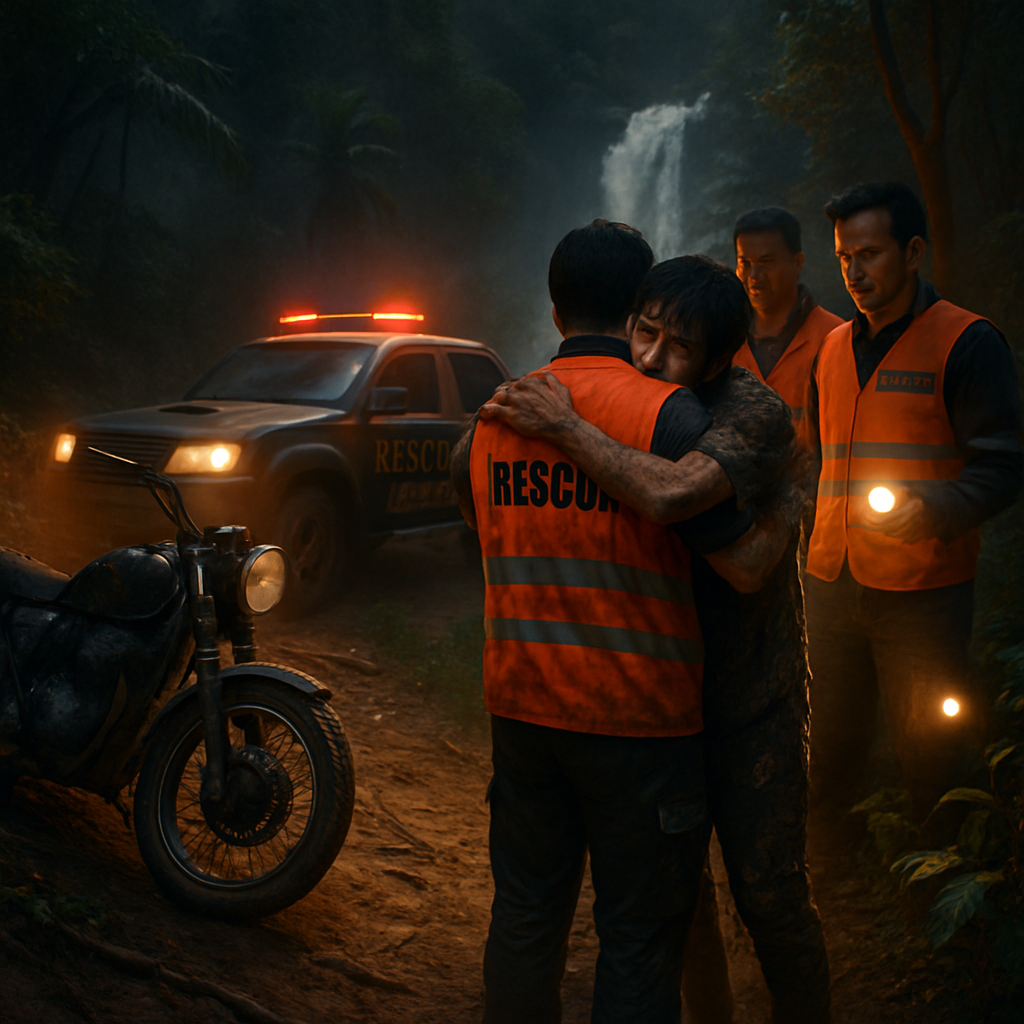
The Sawang Boriboon Pattaya Rescue Foundation received the call at around 7:00 pm reporting a stranded rider in Pong subdistrict, Bang Lamung, Chon Buri. Rescue teams scrambled, deploying off-road vehicles to reach the Khao Phai area where Huay Yai police were already assisting the tired and dirt-smattered rider. Witnesses described him as exhausted and grateful; he had walked more than 2 kilometres through thick undergrowth to find help.
Punnyawat’s bike — a black Honda CL 300 — fared better than its rider. The motorcycle sustained only minor damage and was recovered by rescue workers later that night. But the image of a young man, covered in mud and carrying the day’s disappointment like a souvenir, was striking enough to spark renewed warnings from locals and authorities about the limits of navigation apps in rural Thailand.
When “Turn Right” Means “Turn Wrong”
Punnyawat told rescuers he set out to photograph Krok Ma Tai Waterfall, guided by GPS from Highway 331. The device led him onto a narrow, hazardous track that quickly deteriorated into steep slopes, running streams, and dense forest. As daylight faded, the motorcycle toppled on a hillside and was too heavy to lift alone, forcing him to abandon it and make his way out on foot.
“GPS is brilliant most of the time, but it doesn’t always understand the difference between a paved road and a goat trail in the jungle,” said a local villager who asked not to be named. In regions where official mapping data can be patchy, digital routes sometimes take users down logging tracks, service roads, or merely worn paths that should never be trusted by unsuspecting motorists.
Rescue on Khao Phai: Teamwork and Gratitude
Huay Yai police and the Sawang Boriboon Pattaya Rescue Foundation coordinated the response, reaching Punnyawat and later retrieving the motorcycle. Pictures from the scene show the physio bowing and embracing the rescue team — a heartfelt thanks to those who helped him out of the woods.
“I was so relieved when they arrived,” Punnyawat said, according to reports. “I only wanted to take a few photos. I’m very grateful to the police and the rescue foundation for helping me.”
Not an Isolated Case
This incident is a vivid reminder that technology, while convenient, can mislead — especially in rural or rugged areas near Pattaya and across Thailand. Officials warn that mapping systems can’t always distinguish a proper road from a hazardous track. Locals echo that concern, urging visitors to verify routes before venturing into unfamiliar terrain.
Authorities recommend a few simple precautions for travelers planning to explore waterfalls, mountains, and other natural attractions:
- Check multiple map sources — combine your GPS with local maps or official tourism maps.
- Ask locals or park officials for the safest route before you leave.
- Avoid unpaved tracks at dusk or in bad weather; limited visibility makes mistakes far more dangerous.
- Carry basic safety gear: a charged phone, a flashlight, water, and at least one person who knows the area.
A Little Common Sense Goes a Long Way
Punnyawat’s story had a happy ending: he was safe, his motorcycle was recovered, and his gratitude to rescuers was genuine. But his detour is a cautionary tale that many travellers learn the hard way — the fastest route from A to B on your screen might not be the safest route in reality.
So next time your GPS chirps a confident “recalculating,” take a breath, look around, and ask a local. Technology should be your co-pilot, not your sole guide — especially when steep hills and dense forests lie between you and your destination.
The rescue team’s quick response and Punnyawat’s good sense to walk out when he couldn’t move the bike likely prevented a worse outcome. If you’re planning a trip to Krok Ma Tai Waterfall or exploring the wild corners of Chon Buri, do your homework, bring a friend, and remember: sometimes the best directions are the ones you get from people who actually live where you’re headed.


Thanks everyone — I’m okay now and really grateful to the rescue teams. I went to take photos and trusted the GPS, which is a mistake I’ll never repeat. Please be careful out there.
This is exactly why I refuse to trust tech blindly, it’s just lazy navigation dressed as convenience.
Lazy? Or efficient? People should learn basic map reading rather than blaming apps when they mess up.
Map reading? In 2025? Sounds like an excuse for not updating your phone maps or asking a local.
Back in my day we used landmarks and a good sense of direction — saved lives more than these devices sometimes.
Sure, romanticize the past, but the reality is we still need good policies to make rural maps accurate.
Policy and infrastructure both matter; map companies pull data from local authorities — it’s a systemic issue, not just nostalgia.
As someone who studies human factors, I’d say overreliance on automation creates complacency; this incident is textbook.
Exactly — GPS provides a model, humans should maintain situational awareness. The tech isn’t malicious, but it’s not omniscient.
We are working to improve official routing data, but volunteers and private map providers must also cooperate more closely.
Promises are fine but we need faster action — tourists keep getting stranded and it affects local rescue budgets.
If he was a local he wouldn’t have fallen for a goat-track route; tourists need to stop acting like explorers on Instagram.
Blaming the victim is low — he made a mistake but the system set him up; maps should flag unpaved or hazardous tracks clearly.
This could have been deadly if the weather changed or if he was injured; lucky ending but not a happy system.
I guide foreigners all the time — always tell them not to follow ‘shortcuts’ on their phones and to ask locals first.
I agree, tour guides earn their pay by preventing exactly this. Shame apps don’t include local warnings more prominently.
As a solo traveler I rely on both tech and conversations with locals; combine sources and you’ll be fine 99% of the time.
Local villager here — these tracks are known but not for motorbikes, only for farmers. GPS doesn’t ask the locals.
Is it naive to expect map apps to differentiate between paved roads and trails? They should be better at that by now.
Technologically possible, but requires up-to-date ground-truthing; crowd-sourced reports help but need moderation to avoid false positives.
Poor guy — but also kind of hilarious: top 10 travel photos ruined by GPS.
Hilarious only after you’re safe! My photos were muddy portraits of failure, but I laughed later.
From an engineering standpoint, map providers should integrate surface type metadata and light/dusk warnings; it’s a solvable UX problem.
Why aren’t there simple toggles for ‘avoid unpaved roads’ on more GPS apps? Such a basic safety feature.
Some apps have it but users often don’t enable settings. Defaults matter — safety-first options should be defaulted.
We will push for clear labelling of road surfaces and cooperative data sharing with major app companies.
Also, carrying a flashlight and a buddy is common sense. Too many people think they’re invincible with a charged phone.
Tourism boards should publish verified route maps; that would reduce rescues and help local economies safely.
Verified maps would help, but locals must be paid or incentivized to update them — volunteer goodwill fades fast.
We are exploring partnerships to improve rural mapping, but funding and bureaucracy slow the process. Suggestions welcome.
If officials want concrete suggestions: add visible signs at major junctions and coordinate with local communities for markers.
Pilot programs in human-centered signage and app integration often work well; test small, scale up with local feedback.
Why not require map apps to warn when they route through unclassified tracks? It would be a tiny pop-up save lives.
Tiny pop-up is easy technically but it spams users; better is a passive indicator plus hard warnings for certain classes of route.
Honestly, people should learn from stories like this instead of whining online after being rescued.
Rescue teams are paid and underfunded — should we expect them to babysit every tech mistake? It’s a strain on taxpayers.
Blaming the rescued misses the point: invest in prevention and education, and support rescue teams who save lives.
What about holding map companies partially liable for harm when their data clearly misleads drivers? Law could nudge better practices.
Liability is complex — users accept terms of service, but regulators could require warnings and data standards rather than full legal exposure.
People treat GPS like a parent sometimes; we need to teach critical thinking in travel apps too.
Critical thinking is great, but not everyone has the skills or experience — apps should do more to protect novices.
Also ask why routes into sensitive forest areas aren’t blocked — could be environmental damage from off-roaders using maps to find secret spots.
Good point — maps can inadvertently promote harmful tourism to fragile areas; ethical mapping is a thing we need to discuss.
Punnyawat, did you at least come away with a cool story and a better camera angle?
The story is the souvenir — my camera got muddy but my friends love the dramatic ‘almost lost in the jungle’ caption.
Final thought: combine tech fixes, better defaults, local knowledge, and public education — multi-pronged approach wins.
Training people to be better travellers and forcing tech companies to be more responsible sounds expensive; will anyone pay?
Communities, governments, and companies can share costs — when lives are at stake, it’s not optional.
Agreed — public-private partnerships are on the table. We need measurable proposals to move forward.