As Thailand braces for an unusually heavy monsoon season, the country is taking proactive measures to tackle the looming threat of flooding. With rainfall showing no signs of abating, the Office of the National Water Resources (ONWR) has sprung into action, establishing a temporary front-line water management centre to keep a vigilant eye on the deluge predicted to hit the northern regions.
The directive for this initiative came straight from the top, courtesy of Digital Economy and Society Minister, Prasert Jantararuangtong. As the chair of the National Water Resources Committee (NWRC), Mr. Prasert has voiced genuine concerns over the potential for catastrophic flooding, a sentiment echoed by the people who have witnessed the devastation similar events have caused in the past.
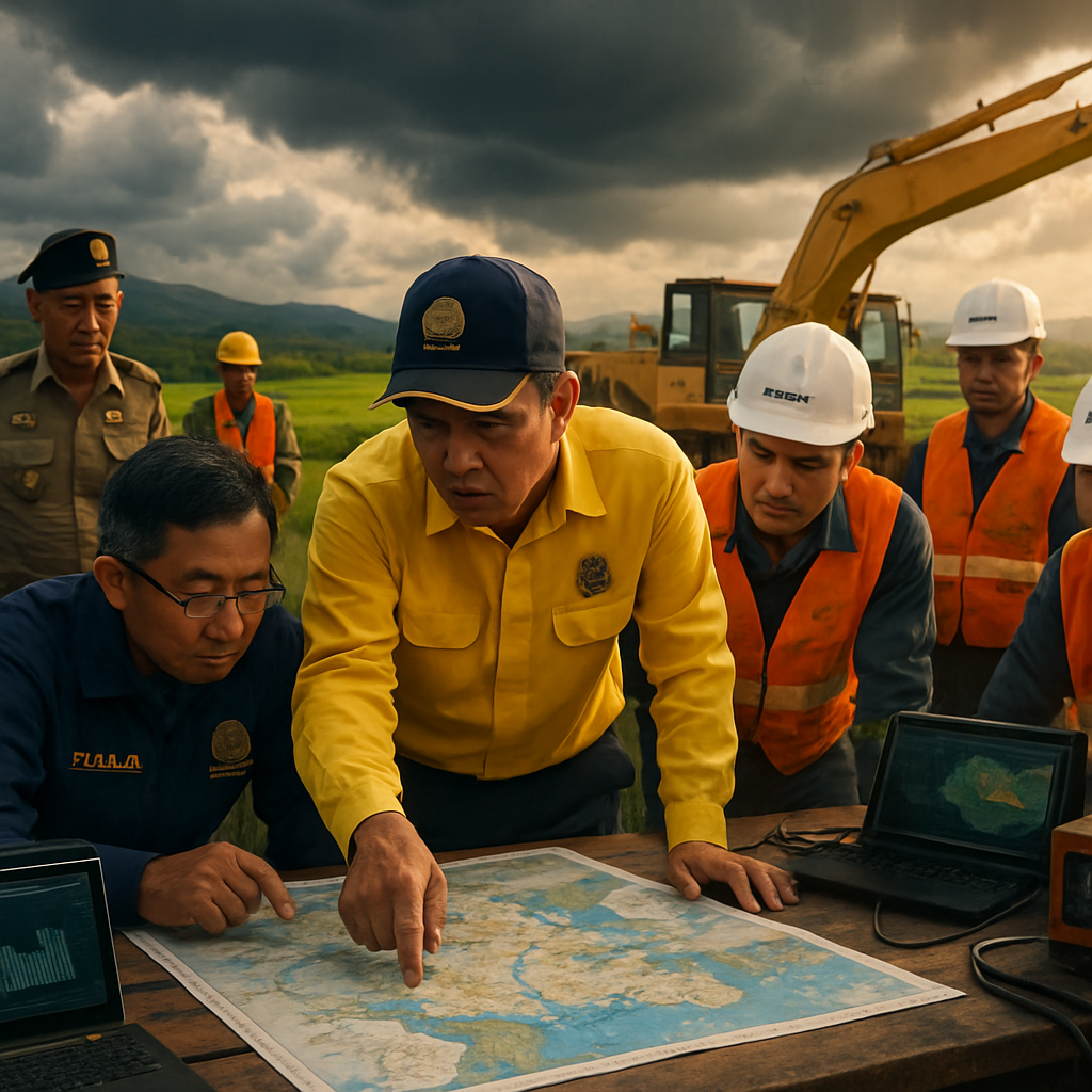
Recently, ONWR deputy secretary-general Paitoon Kengkarnchang convened the inaugural meeting of this newly minted committee in the province of Chiang Rai. It was a veritable who’s who of disaster mitigation, drawing in officials from various local agencies, the Royal Thai Army’s (RTA) Engineer Department, the Thai Meteorological Department (TMD), the Department of Water Resources (DoWR), and the nimble minds of the Hydro-Informatics Institute (HII).
The call to action stems from the palpable fear of severe flooding striking every corner of Thailand. Mae Sai district in Chiang Rai has already been put through the wringer, enduring two substantial inundations this year alone—a disconcerting repetition of the prior year’s afflictions. The TMD and HII have forecasted relentless, heavy rains blanketing northern and northeastern Thailand as well as Laos, making the need for robust flood-management all the more urgent.
The purpose of this temporary entity is twofold: readying emergency responses before disaster harps on their doorstep, whilst fine-tuning flood monitoring and alert systems in battered districts like Mae Sai. The agencies involved have amplified their vigilance, leveraging flood maps and the TMD’s sophisticated meteorological radar to navigate through these stormy waters.
The Hydro-Informatics Institute is flexing its technological prowess by integrating a Mobile Mapping System (MMS) and online 3D maps to enhance district water management. Simultaneously, the Royal Irrigation Department (RID) and the DoWR are revisiting reservoir management strategies to ensure minimum upheaval to daily lives.
Moreover, the coalition of local agencies and academic institutions is doubling down on their research efforts to bolster flood forecasting and mitigation. Armed with findings that spotlight regions prone to deluge, they aim to refine both preparedness strategies and early warnings.
However, it’s not just the infrastructure that needs reinforcing. As of Wednesday, the torrential rains have severely impacted areas around Chiang Mai, with districts Doi Lo and San Pa Tong witnessing the brunt of it. Occupying a less fortunate spot under the persistent downpour from May 25 to 27, these regions have experienced flash floods and mudslides, leaving local authorities scrambling to provide immediate aid and cautionary advisories to residents.
Despite these challenges, the RID’s Office 1 has reported a silver lining: the two largest reservoirs in the northern territory still boast substantial unused capacity. A beacon of hope, signaling that amidst the potential chaos, there’s still space—an opportunity to mitigate, to prepare, and perhaps, to protect.
As the clouds gather, Thailand marches forward with a mix of anxiety and resolve, determined not only to weather the storm but to emerge resilient, ready to face whatever the skies may send their way. The residents, meanwhile, watch the skies, hope in their hearts, and determination in their step—a microcosm of a nation ready to stand against the elements.


I’m glad Thailand is taking these steps, but why wait until disaster is at their doorstep? Shouldn’t they have had a better system in place years ago?
That’s a fair point, but at least they’re doing something now. Better late than never, right?
Sure, action is good, but recurring disasters need more than temporary setups.
These are systemic issues. Blaming the current administration won’t solve the root causes.
It’s amazing how technological solutions like Mobile Mapping Systems are being used. I hope this becomes a model for other countries facing similar issues.
This is just a Band-Aid solution on a much bigger problem. Climate change is the real issue.
Absolutely, if countries don’t address climate change, we’re just going to see more of this.
Exactly! We need big changes, not just stop-gap measures.
I’m skeptical. Every year we hear about these plans, yet the impact seems the same. Are these meetings actually effective?
How can they predict monsoons with such accuracy? It seems like guesswork most of the time.
It’s not guesswork. Meteorology has come a long way. The problem is nature can still be unpredictable.
I see your point, but if predictions aren’t foolproof, shouldn’t we be taking a more adaptive approach?
The reservoirs being under capacity is good news, but what happens when those fill up? We need spillover plans.
All the agencies involved are doing their best, but local communities need to be part of the solution too.
Yes, local knowledge can make a big difference in tailoring responses to each community’s needs.
I think Western countries could learn something from how Thailand is handling this. Collaboration is key.
The ONWR has launched impressive initiatives, but collaboration could be stronger.
Exactly, they need more grassroots involvement and external experts.
Sounds like political grandstanding to me. Are they really interested in the people’s wellbeing or just votes?
It’s easy to dismiss, but it’d be unfair to entirely discredit the intentions here.
More academic institutions should take part in collaborative research. Knowledge is power.
We also need to talk about funding. Where’s all this money coming from?
Hopefully from areas where it’s less urgently needed. It’s vital infrastructure.
The army’s involvement is interesting. Is this a military operation or a civil one?
Wonder what measures they’re planning for the animals and wildlife in those regions.
Great that they’re prepping, but will this create long-term sustainability?
The technology used for mapping is probably the most exciting thing about this.
Agreed, tech can really make a difference when integrated well.